Architecture Overview
If you need a brief introduction to the technical architecture of Indicia, then read on.
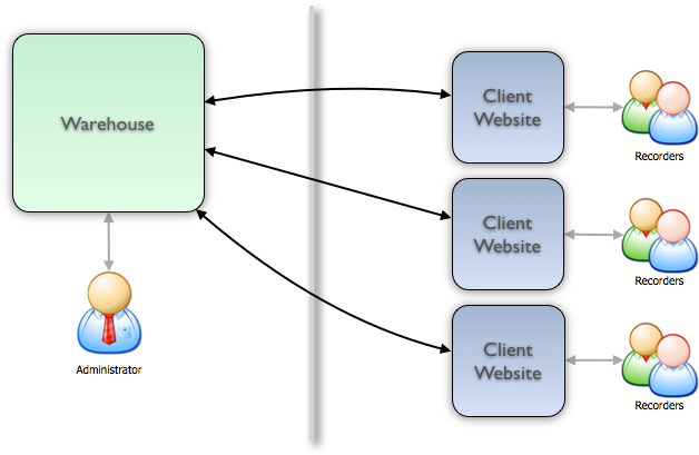
A website built using Indicia consists of 2 main components:
- The warehouse
- The client website
The warehouse consists of the database itself and administration tools as well as a set of web-services which allow the client website to communicate with it. The client website is the part which hosts the online recording, reporting and other pages which the end-user sees. Indicia uses a distributed architecture, meaning that the client website and the warehouse can be on separate machines connected only via the internet. The division into two components serves to keep the administration interfaces and the end-user interfaces completely separate. Also, a fully featured online recording solution makes heavy demands on the server technology, in particular to allow it to properly support spatial data. Therefore this separation allows a single warehouse to be shared between multiple client websites. As long as partner able to host a warehouse can be found, the server technology required to run online recording on a client website is minimal. In fact, most cheap web hosting services will support Indicia based online recording client websites.
Warehouse architecture
The following diagram illustrates the basic architecture of the warehouse.
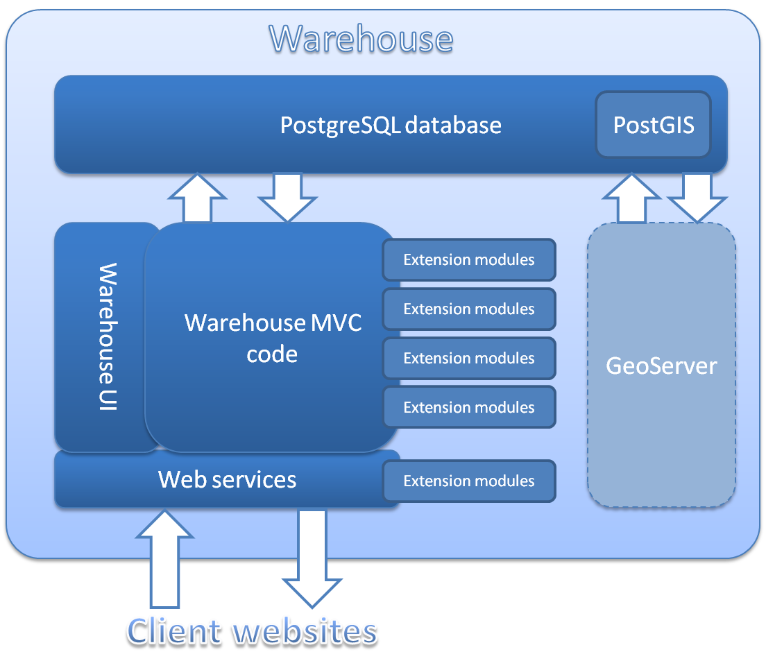
There are quite a few acronyms and other bits of jargon but don’t worry, we’ll work through each of these in turn.
PostgreSQL
PostgreSQL is a relational database management system. In essence, a relational database is a collection of tables of data, each of which may relate to rows (records) in other tables in the database by the use of unique identifiers. PostgreSQL is just one of many pieces of software that are designed to manage relational databases, letting you store and extract the data in powerful and flexible ways. Each makes claim and counter-claim regarding which is the fastest, which can hold the most data and so forth. Our choice of PostgreSQL is based on:
- It has a free and open source community edition which we use for Indicia
- It is at least similar in performance, flexibility and power to the other, proprietary commercial offerings
- When combined with PostGIS, it has better support for spatial data than most alternatives, that is, data which have geographic information attached to them. The most commonly used database for website development, MySQL, is rather poor in its support for spatial querying in comparison. We’ll find out more information about PostGIS in a moment.
- It is actively being developed and continually improving.
PostGIS
PostGIS adds support for geographical information to PostgreSQL. A database that supports geographic data is often called “spatially enabled”. Not only can PostgreSQL + PostGIS store map data directly in the database, but PostGIS adds a whole plethora of functions for transforming between different cartographic projections, measuring, manipulating and otherwise interpreting the geographic objects it stores. For example, PostGIS can:
- convert the boundary of a place from a latitude and longitude map projection to British National Grid projection,
- find all the records within 200m of a river,
- let you report on the data in a user-drawn polygon which can optionally be buffered.
Warehouse MVC code
Warning
Jargon alert!
The code for the warehouse is written in PHP and uses a framework called Kohana. Kohana is one of a number of frameworks that use the Model View Controller (MVC) design pattern available for PHP. By using a framework rather than starting from scratch we get a collection of useful code for accessing the database, building the user interface and business logic. As an MVC framework, Kohana also provides a standard way to organise code classes into logically separate roles:
- Models - classes which interact with the database. Each model class normally represents a single object in the database and provides methods to insert, delete and modify records as well as properties to inspect field values from the database.
- Views - code which provides the user interface. In our case these are PHP files which output HTML.
- Controllers - classes which manage the business logic and interactions between models and views.
Kohana’s framework allows for additional modules which can extend existing functionality and provide new functionality.
Indicia’s warehouse code adds lots of useful code to Kohana including helper classes for handling different grid reference notations, managing vague dates and a host of other online-recording tasks. In addition the extensibility of Kohana is augmented to provide a simple way to add new data tables, screens, and tabs to the existing warehouse user interface.
Warehouse UI
The warehouse user interface code consists of a series of Kohana views. Each
view is a simple PHP file which outputs the HTML required for the view. For the
most part, the warehouse code uses the same client helper library API for the
user interface code as client websites. For example, the grids you can see in
the warehouse when browsing data are the same report_helper::report_grid
component used to add grids to client websites. However, because Indicia’s
warehouse was originally developed in parallel to the client helper library,
some of the earlier views utilise the HTML helper provided by Kohana to generate
the HTML output. These are being converted to use the client helper library API
to keep the code consistent, but this is a lower priority than many other tasks.
Likewise, the import facilities available on the warehouse are use the exact
same import_helper class as the one provided in the client helper library
API to build import facilities for client websites.
Web services
As you can see from the earlier diagram, the web services are key to the interactions between the client website and the warehouse. Web services use the same protocols that we use everyday for browsing the internet but instead of providing a user interface (website), web services provide a programmatic interface. In a typical web transaction, a user sends a request to a specified web address. The server responds with the web page. A typical web service transaction is instigated by some code on the client website. The code sends a request to a specified web address. The server responds with some data. The code then processes that data before rendering the web page as appropriate.
The web services in Indicia are comprehensive in comparison with some systems where the web services were added as an afterthought, because the Indicia architecture means that every single interaction with the data on the warehouse must go through the web services. Every record, every report and every map you see on websites like iRecord is obtained via the web services. Indicia’s web services provide the following facilities:
- Data services
- Read individual database records
- Read lists of database records according to provided sort and filter criteria. This supports pagination in grids by allowing limit and offset parameters
- Write to records for edits and deletes
- Reporting Services
- Read the output of reports, also with support for pagination in grids by allowing limit and offset parameters
- Other web services
- Authenticate a client website
- Spatial reference operations including transformations from map coordinates to and from any spatial reference notation.
- Bulk import records
- Apply verification rules to proposed records
The data access via Indicia’s web services requires secure authentication and applies authorisation so that each client website cannot see data that belongs to other websites by default.
Extension modules
The Kohana framework provides useful support for extensibility via the concept of modules, which allow the provision of additional models, views and controllers as well as the overriding of existing code from the main application. Indicia’s warehouse extends this idea by allowing modules to hook into various bits of core functionality. For example, Indicia allows a module to provide additional items to add to the main menu or new tabs for an existing page. Indicia’s module framework can even be used to extend the data model with completely new entities and attributes and to support accessing these via the web services. Therefore any extensions to the data model which are not likely to be useful to the majority of online recording surveys should be implemented via modules, helping to keep the core of Indicia lightweight and efficient.
Example modules which extend the data module include:
- taxon_designations for supporting designations information for species.
- individuals_and_associations for supporting records of individual organisms and the associations with others, e.g. ringed birds or family groups.
GeoServer
GeoServer is an open source software server that allows users to share geospatial data. GeoServer publishes data using open standards and therefore provides an ideal platform for publishing Indicia’s PostGIS spatial database over the web. Data can be published directly as map images or layers for overlay onto web mapping applications and GIS applications, or a variety of text based spatial formats.
GeoServer is a separate optional installation which should sit alongside the warehouse on the same server. Although Indicia is capable of drawing maps without GeoServer, any attempt to map more than a few thousand points on a single map is likely to hit performance problems both in the browser’s JavaScript engine (which is responsible for adding points to the map) and because of the size of the download file. One option that GeoServer provides is a Web Mapping Service (WMS) which renders the map layer image on the server and sends the image to the client. This results in drastically improved performance when rendering maps with large numbers of records.