Shortcuts for form building
Because quite a few forms have a lot in common with each other, the prebuilt form library includes some handy PHP files containing shared code. In most cases the examples include arrays of standard parameters you can include in your form’s parameters, along with standard code for building form output using these parameters. We’re going to take a look at how this technique can be used to add standard configuration parameters for the map on our form.
First, you will need to add the includes/map.php file to your tutorial.php file, by adding the following near the top of the PHP (I normally like to put this code immediately beneath the first comment which describes the file):
<?php
require_once 'includes/map.php';
?>
Now, let’s add some standard parameters to our form. The map.php file we’ve
included has a method called iform_map_get_map_parameters which returns
an array of parameters ready for inclusion. We can use PHP’s array_merge
function to add these parameters to our standard ones by updating our
get_parameters method as follows:
<?php
public static function get_parameters() {
  return array_merge(array(
    array(
      'name'=>'survey_id',
      'caption'=>'Survey',
      'description'=>'The survey that data will be posted into.',
      'type'=>'select',
      'table'=>'survey',
      'captionField'=>'title',
      'valueField'=>'id'
    ), array(
      'name'=>'taxon_list_id',
      'caption'=>'Species list',
      'description'=>'The species list that species names can be picked from.',
      'type'=>'select',
      'table'=>'taxon_list',
      'captionField'=>'title',
      'valueField'=>'id'
    )
  ), iform_map_get_map_parameters());
}
?>
Update your tutorial.php file and save it, then load the edit page for your form in your web browser. You’s see that rather than just the Other IForm Parameters section for form configuration, there are now 4 additional categories of settings for various mapping options.
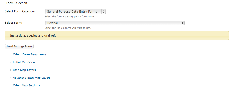
At the very least, you should expand the Base Map Layers section and tick at least one of the Google layers to show on your map.
As before, having added the new parameters to our form we must also change the
code so that it makes use of them. The map.php file provides helper functions
for this as well. Look at your existing get_form method in the tutorial.php
file and find the existing line which calls the map_panel method:
<?php
  ...
  $r .= data_entry_helper::map_panel(array(
    'presetLayers' => array('google_streets','google_satellite')
  ));
  ...
?>
Rather than passing a hard-coded set of options to the map panel, this code
must now use the map.php’s helper functions to get the array. Note that not
only is there an array of options to pass to the map_panel method, but
there is a second array of options to pass direct to the OpenLayers
JavaScript object, though this is optional and won’t be covered in this
tutorial. You can find out more about these options in the OpenLayers
documentation.
The code to use the map.php’s helper functions is as follows:
<?php
  $mapOpts = iform_map_get_map_options($args, $auth['read']);
  $olOptions = iform_map_get_ol_options($args);
  $r .= data_entry_helper::map_panel($mapOpts, $olOpts);
?>
Note
OpenLayers is the name of the JavaScript library Indicia uses to add maps to web pages.
By adding just a few lines of code to link in the functionality provided by the map.php file, we’ve enabled a substantial amount of configuration for our map including:
Choice of base layer(s) from one of several web mapping standards, or even a custom web mapping service.
Display width and height of the map.
Initial latitude, longitude and zoom scale for the map, which can default to the global settings for the site if preferred.
Ability to remember the map’s last used position.
Ability to add overlay layers from web mapping services.
Configuration of the list of controls available on the map - you can even setup polygon or line based recording using the drawPolygon or drawLine controls!