Taster
Ok, we know that Indicia is about building online biological recording websites using a suite of tools services and components. But what sorts of things might I expect to get? This section illustrates just a few examples but don’t forget that Indicia is open source and fully extensible so there are no limits to what can be achieved.
Data entry
Inputting a species in Indicia can be via a variety of techniques including picking from drop-down selection boxes, checkboxes or inputting into a text box. For the latter it is commonplace to provide a drop-down list of possible selections.
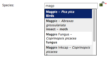
Note that the recorder is informed of the species group they are picking from as well as the preferred name of the species, so the chances of mistakes when selecting “dangerous names” are drastically reduced. The species search is also clever enough to tolerate differences in punctuation or spacing in the names, e.g. is it a 7-spot or a 7 spot ladybird? The species autocomplete control in this screenshot has a handy lock icon after it which holds the value for the next time you use this input form - very useful if inputting a list of sightings of a single species at different places or on a single date. The lock option can of course be configured to be available for any control you feel it is appropriate for (the date or grid reference are both good examples).
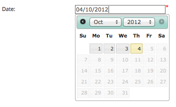
Entering other types of information about each record is supported through a library of controls. Here the date picker ensures that the recorder always inputs a valid date, though of course it is configurable to allow vague date entry if you prefer. 352px
When you use an Indicia provided data input control you get a range of functionality options straight out of the box that you would otherwise have to configure for yourself. These include:
Saving the value to the database is handled for you
Loading the value back from the database for editing is handled for you
The ability to lock the value so it is remembered next time you use the form
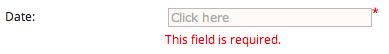
Validation rules are applied to the control and messages displayed to the user as approriate
As an example of the latter, here’s the above date_picker control having tried to save the record without filling it in:
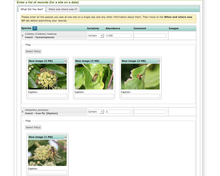
Species entry in Indicia can be via any method that is appropriate to the survey, but in many cases when entry of multiple records is required the species checklist control can be configured to allow appropriate and rapid data entry that suits the survey’s needs. Here the grid is configured to allow basic record data but the attributes available for input in the grid can be configured as appropriate to the survey methodology and/or species group being recorded.
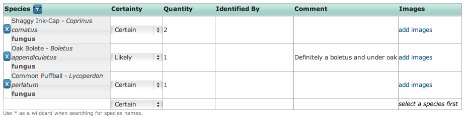
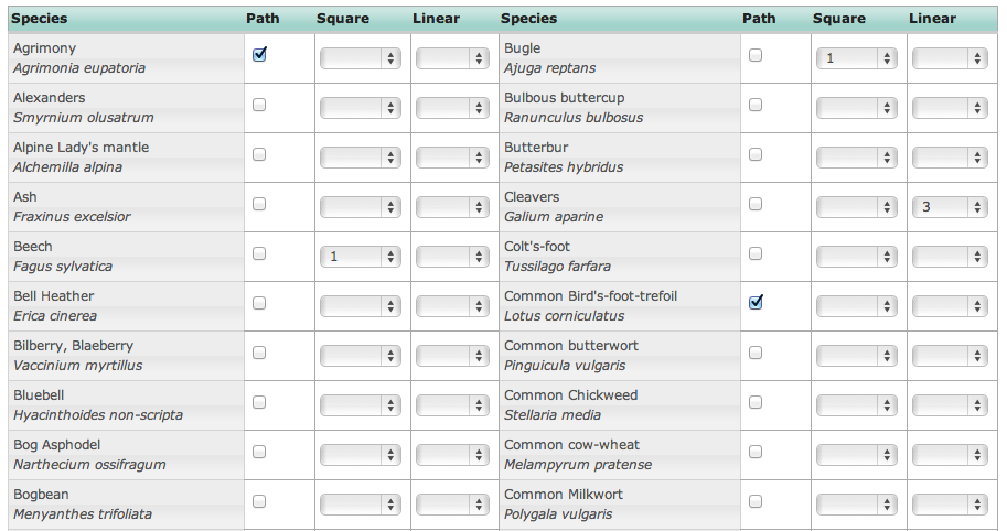
The species_checklist grid control is highly configurable, for example it can be configured to allow ticking off of species from a preset list rather than to input an arbitrary list of species. In this instance recorders tick off species against a preset list of wildflowers and can specify which part of the survey plot the species was found on.
The grid also allows upload of photos for each record. Resizing of images is handled from within the browser meaning that photo upload times are drastically reduced, making it feasible to upload substantial lists of records and photos into Indicia based online recording forms.
Entering a grid reference for the records via a click on a map ensures that transcription errors in grid references are a thing of the past.
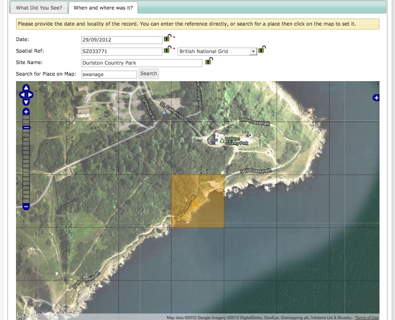
Grid references can of course be input directly into the text box when available. Rather than force all records to be linked to a site even for ad-hoc records, the link between a record and a site is optional in Indicia and every record has its own unique grid reference, reducing the chance that a record will be mistakenly recorded at the centre point of the site.
Todo
BDS showing species identification notes
Reporting
Many Indicia reporting requirements are met by the flexible report grid control which is designed to output tabular data and supports filtering and sorting out of the box. Here the grid has been configured to include thumbnails of the photos associated with each record.
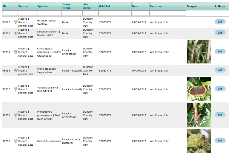
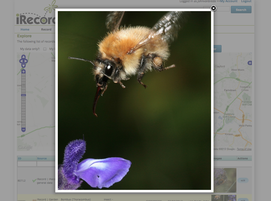
Clicking on a photo thumbnail in any grid zooms the photo for a closer look.
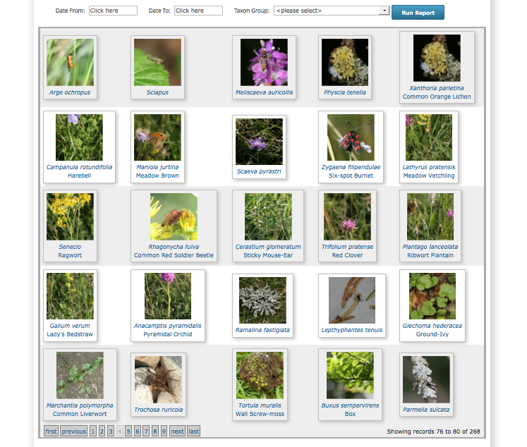
The report grid control is flexible enough to be reconfigured as a photo gallery, here showing a simple parameters form for selection of the date range and/or species group to show photos for.
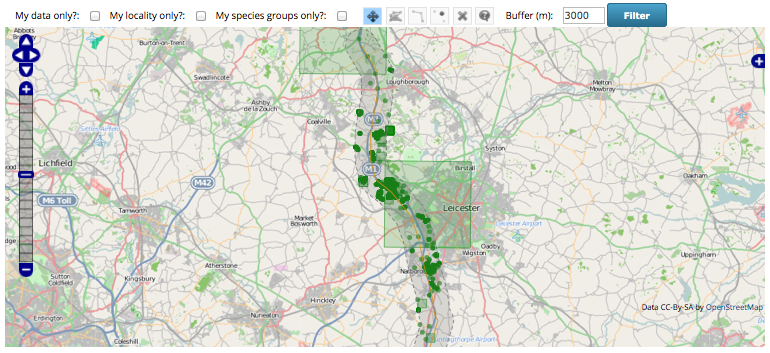
Indicia’s reporting capabilities also allow you to output report data onto maps or charts. The following map shows a buffered report for records in a 3km zone around the M1 corridor, with records shown at their original precision including a couple of rather imprecise 10km records:
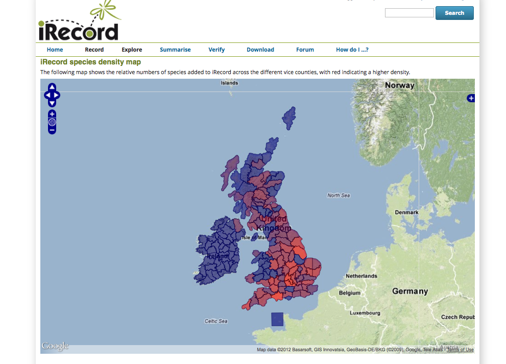
Maps can show aggregated information as well as simple records. Here a layer of British vice counties is combined with the records data to produce a density map of species on iRecord. Obviously this is more reflective of recording effort at this stage rather than any real indication of species diversity.
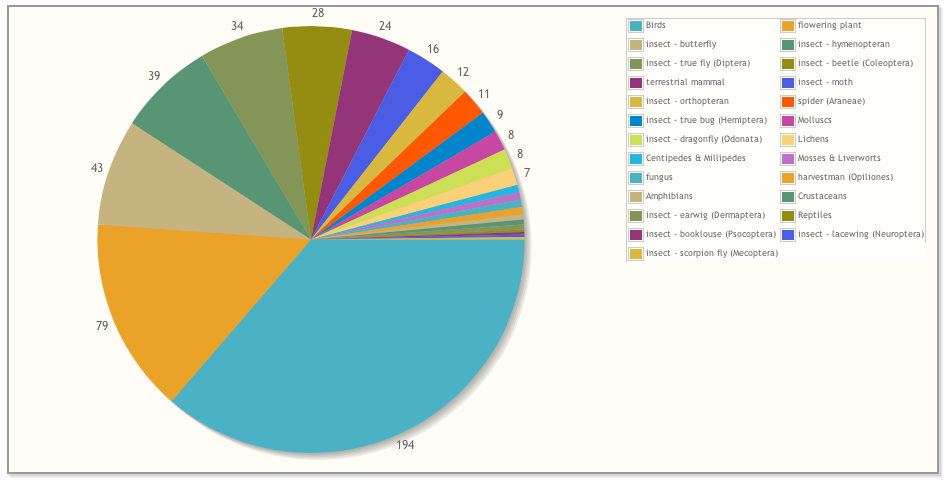
Charting with line, bar and pie charts is also supported for any suitable report data. The following pie chart shows the species groups I’ve been recording this year with the pie size indicating the number of species for each group.
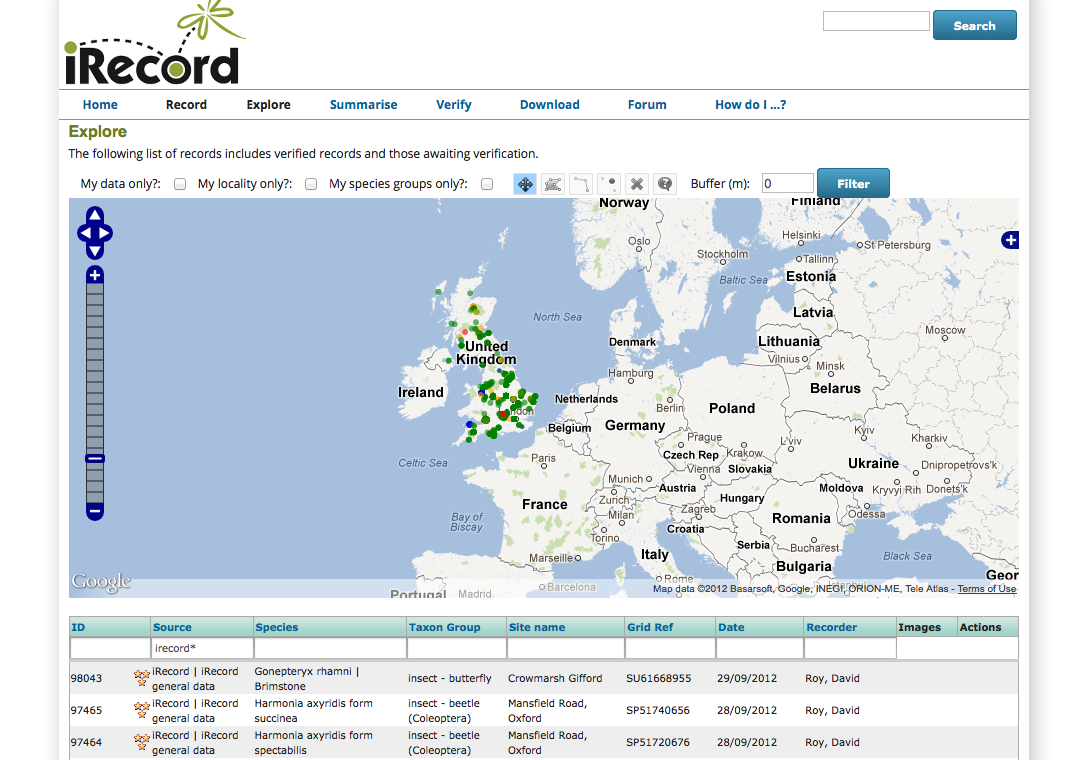
Indicia allows synchronisation of the data between multiple reports, charts or maps on a single page. For example you can build a page showing a map of records along with a table showing the distinct species and a pie chart of a breakdown by species group on a single page. Here the Map Explorer prebuilt form combines a map with a simple table of the records shown on the map. The grid can be filtered and sorted with the changes kept in synch with the map display. This example is from the iRecord Explore facility.
Verification
Although Indicia started out as a toolkit for the online capture of wildlife records, it was obvious from the outset that there were many other potential benefits of the online approach. Providing a centralised online verification tool is one such benefit, since records can be immediately available to verifiers and there are opportunities to increase the efficiency significantly using automated checks, rapid verification and other tools. Indicia includes a ready made verification system as used on iRecord:
Todo
Verification image
Bulk import
Todo
Complete bulk import taster
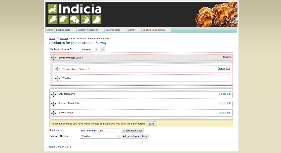
Survey Management
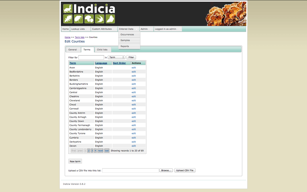
When you build an online recording website there are a number of things you will need to be able to configure, such as lists of species to record against or lists of terms to provide options for drop-down boxes on your forms. In Indicia there is a back-end website called the warehouse which you can log into as the administrator of a recording website, but which your recorders will never log into. This provides a simple user interface for setting up the various supporting data required by your online recording form, including bulk import from spreadsheet files, browsing, adding, editing or deleting any item of data.
One of the reasons why you will log into the warehouse is to configure new surveys. For each survey you setup you can choose which custom attributes to include on the recording form; you can even create completely new ones and define the allowed values, validation rules or any other aspect of the attribute. This means you can build recording forms that are as simple or advanced as you want. There is even a drag and drop editor which lets you define the organisation of the attributes that will appear on your recording forms: