Locations and sites
Indicia allows for ad-hoc entry of samples at any location as well as samples linked to explicit locations described in the database. If a record is made at a location where there is no benefit from defining additional data about the site, or repeat recording at that site, it is acceptable to input a sample which stores the geometry of the sample location in the samples.geom field. This geometry will typically be a point, buffered point including inaccuracy information, or grid square, but might also be a transect line or other geometry. No other metadata relating to the polygon itself is collected in this instance (other than the point-in-time attribute values captured with the sample). Note that the samples table can hold a simple hierarchy of surveying event information, for example a sample could be created to hold the line of a walk, plus sub-samples for the locations along the walk where records were taken.
Once a polygon needs to have some sort of persistent meaning in the database, for example a site that may be revisited, or an administrative boundary, it should be stored in the locations table. The location has traditional fields such as a name (locations.name) and the spatial reference (point or grid square) of the centre (locations.centroid_sref). It has separate geometry fields for the centroid and boundary (locations.centroid_geom and locations.boundary_geom). So, in a typical locations record, the centroid_sref and centroid_geom fields will describe the point or grid square at the centre of the location and the boundary_geom provides the polygon describing the boundary.
There are several fields involved in storing spatial data in the samples and locations tables. In summary:
Fields named *_geom in the samples and locations tables are all proper spatial objects (GEOMETRY data type) that use the PostGIS extensions for PostgreSQL. They can store points, polygons, lines and other geometries. This means you can use the rich suite of PostGIS functions in your queries. The default behaviour of Indicia is to store them in Web Mercator projection (EPSG:3857) which avoids the need to reproject geometries when they are drawn over the majority of widely used web mapping services.
Fields named *_sref in the tables hold the spatial reference in the format it was originally input by the recorder. This may be an x, y coordinate, a Latitude and Longitude in one of several formats, or a grid reference notation if supported by Indicia. E.g. “54.123N 0.876E” or “SY010203”.
Fields named *_sref_system in the database either provide the EPSG code of the system for the text in the *_sref field, or a brief code which defines the notation and projection in use. For example, it will hold “4326” for WGS84 GPS latitude and longitude, or “OSGB” for Ordnance Survey British National Grid notation (which uses EPSG 27700 implicitly as the underlying projection). Where an alphabetic code is given for a spatial reference notation, there must be a matching module installed on the warehouse to handle the intepretation of this grid system’s notation.
Once a location has been added to the table, it may be used in several ways:
As a filter for generating report outputs.
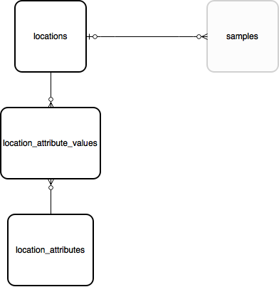
Linked to a sample using a foreign key in samples.location_id. Note that a sample may lie inside a boundary of a location without the sample linking directly to the location - this means the relationship to the location would need to be implied by a spatial query rather than a traditional database relationship.
Any layer of locations which is frequently tagged against a record (e.g. vice counties or other region) can be indexed using the warehouse spatial_index_builder module. This module then runs spatial queries to link all the samples in the database to the locations in the indexed layer and stores these links in the database. For example the cache_occurrences.location_id_vice_county field gives a direct link to a record’s vice county in the BRC warehouse configuration.
Locations support custom attributes so can be extended to support any metadata you require.
See Locality data for more information on spatial data in the database.
Ref. locations