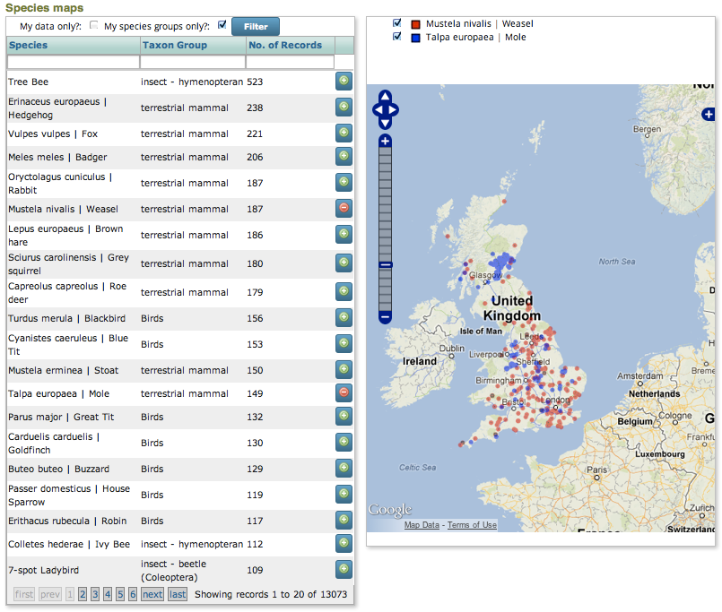
Quick Species Maps
The Quick Species Maps prebuilt form provides a simple way of doing distribution maps for recorded species, with the ability to compare up to 4 species on a single map. A grid listing recorded species with numbers of available records is shown, plus controls for easily adding or removing a species from the map.

This page type requires GeoServer to be set up on the warehouse,
with a layer defined that exposes a list of occurrence records including the species’
external_key (taxa_taxon_lists.external_key field). You will need the name of this
layer layer when you configure the form. If you are the administrator of the warehouse you
are using, then for more information on preparing GeoServer on the warehouse see
Setting up GeoServer. Otherwise please ask your warehouse
administrator for further information on the availability of GeoServer on your warehouse.
Tip
GeoServer is the name of an open source tool which enables access to your records via spatial web services, in other words it makes it really easy to drop your records onto maps.
To use the Quick Species Maps prebuilt form on an existing Drupal site with the Indicia forms module installed, simply select Content > Create content > Indicia pages from the admin menu then set the page title, menu and other general settings as you would for any other Drupal content page. In the Select Form Category drop down choose Reporting then Quick Species Maps. Click the Load Settings Form button to bring up the Quick Species Maps specific settings. The settings you will need to consider include:
Todo
Link to details of standard settings for reporting and mapping.
Feature type for Indicia species layer - this must be the name of the layer on the GeoServer which will be used to access the records. The name is constructed from the namespace, followed by a colon, then the layer name.
Field to filter on - this must be the name of a field exposed in the data for the above layer which contains the taxa_taxon_list.external_key field. This field is often used to store a unique identifier for each organism in the dictionary of species held within the Indicia warehouse, so records with the same external_key will be the same species.
SLD files from GeoServer for Indicia species layer - because this page allows more than one species to be added to the map at a time, it is important to specify several styles which can be automatically cycled through as the species are added to the map, ensuring that the species layers can be differentiated. GeoServer uses a standard file format (called SLD, or Styled Layer Descriptor) for defining how map layers are drawn, which can define things like the line thickness, fill colour and opacity or symbol to draw as well as to define how the appearance changes depending on the data values. This can be used to define the dot size according to a data value for example. Because this technology takes place on the server rather than on the client it can be a very fast and powerful method of mapping records, though the downside is that SLD is a moderately complex file format. However there are a handful of default SLDs installed with GeoServer and your warehouse administrator may have set up some more for you, e.g. for drawing distribution points in one of several colours.
